
This is part 1 of what I hope to be a three part report on my trek to and from the the rec.aviation fly-in at the Pinckneyville-DuQuoin airport, PJY. My memory isn’t 100% and I think next time I’m going to bring my laptop so I can start writing this stuff while it’s still fresh in my mind.
Friday, Mark and I were ready quite early. I won’t deny that a bit of pre-flight excitement and nervousness made it hard to sleep. The weather didn’t look great for the first bit of the flight – along the lake shore to Cleveland, there was an airmet for occassional trace to light rime or mixed icing in clouds or precipitation between the freezing level and somewhere in the flight levels. In other words, the same airmet that sits over Rochester all winter long. The only difference is that unlike Rochester in winter, the clouds were going to be in several layers, and the freezing level was at 5,000 feet. This was a perfect opportunity to put all that practical advice about dealing with icing from IFR and IFR Refresher magazines. There was also going to be some precipitation, but no convective activity (ie. thunderstorms) to speak of.
There were VIP Temporary Flight Restrictions in Chicago and Cinncinatti indicating that the President and Vice President were probably on the move, but fortunately my route went just about half way between them.
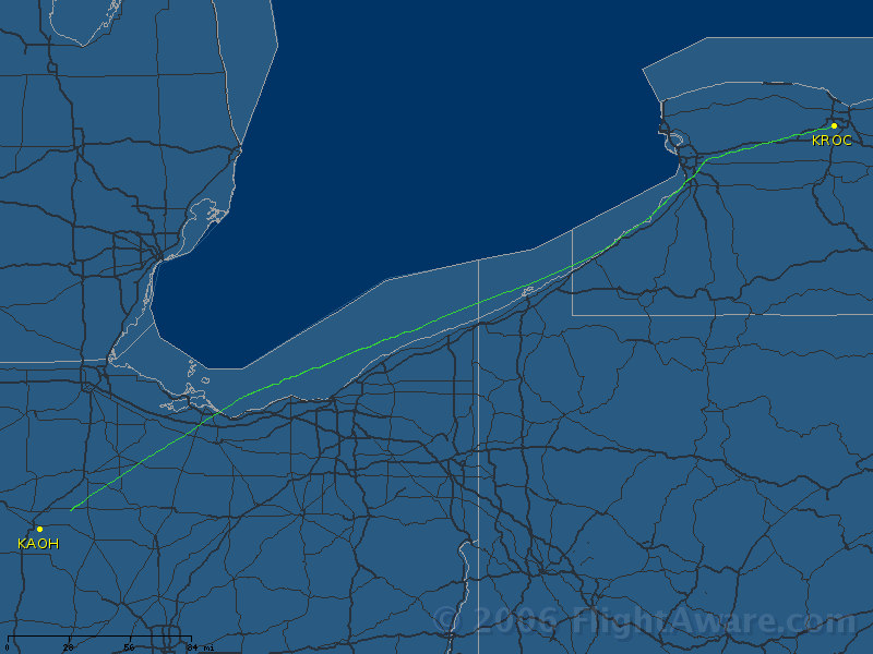 So I filed IFR for 8000 feet for the first leg from Rochester to Lima Allen County (AOH), somewhere in Ohio. The plane was a bit reluctant to leave the ground since we were pretty close to max gross on a warm day. But once airborne it climbed pretty well. We climbed out through a solid layer and were soon on top in billiant sunshine at about 2500 feet. But shortly afterwards, as we continued our climb, we went through another layer of clouds and were once again on top. This time we’d picked up a tiny bit of ice, but once we got into the clear again it was sublimating away pretty quickly. After I levelled out, though, I noticed a bit of strangeness in the way the VSI (Vertical Speed Indicator) was reacting compared with the Altimeter (and cross checked against the “fake panel” on my GPS). Then it hit me, I’d forgotten to put on pitot heat on the way through the clouds. I turned it on, and the VSI immediately showed an immediate +2000 fpm climb (which is impossible in that plane in just about any circumstances) and then quickly went back to no climb, while the altimeter showed me 250 feet higher than my assigned altitude. I guess the static port got a little iced.
Not too much later, a cloud layer built in on top of us and started sloping down towards us. As it reached us, again I got a bit of ice, so I asked for and was soon given lower and the ice went away. Then the cloud above went away and so I asked for my previous altitude of 8000 and was given clearance back. Around that time the Erie controller told me that Cleveland didn’t want me on Victor 14 going through their airspace since that’s a route they use for jet departures. They gave me a choice of going south through Akron and a VOR I couldn’t find on my chart, or north to Sandusky VOR, which I could find on my chart. So I chose Sandusky. That route puts you a bit off the shoreline, but at 8000 feet I had a lot of glide distance if something went wrong.
Passing through Cleveland, the clouds started coming up from below and filling in above. At first I asked for 10,000 feet, which put me above the clouds from below but the ones above were coming down, and soon after passing Sandusky I had to ask for a descent to freezing level. They cleared me down to 7000 feet and said if I needed lower I should ask it. But 7000 was between layers and the ice was coming off, so I kept it. And not long afterwards it cleared both above and below and we could see forever. The controllers also got a lot more laid back and I got to keep a radio frequency for longer instead of switching ever few minutes. Things were mostly uneventful from there to the fuel stop – I cancelled IFR about 15 miles out because I could see the airport and they said they were about to lose me on radar.
The FBO at Lima Allen County had a DTN weather setup – there I could see a bunch of nasty stuff in a line going straight south from Chicago down towards Pinckneyville and points south. It didn’t look like it was going to be possible to fly around it. However, the briefer was of the opinion that it was breaking up and in the two hours it would take us to get there things would be quite different. So I took off with the intention of staying in VMC until I could see this line visually and/or on the Stormscope and get a feel for things, and if it was still bad we could land and wait for it to dissipate and maybe arrive later Friday or even early Saturday.
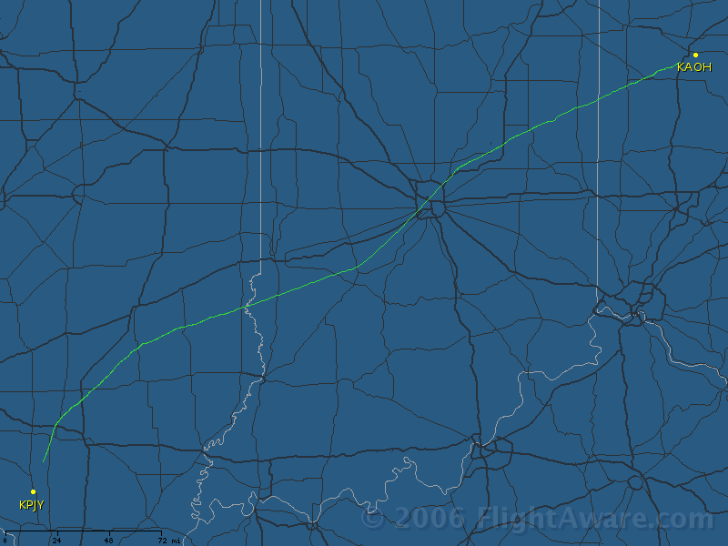 As expected, it was pretty easy to stay in VMC, and my preferred altitude 8,000 feet was below the freezing level down there. About half an hour from where I expected to find that weather, I wasn’t showing anything on the Stormscope and I asked the controller if he could see anything on his radar. He said there was a cell about 40 miles south of us, and nothing else. And as we got to Bible Grove VOR, we actually passed between two extremely light rain showers, but didn’t get wet. We made the turn towards PJY and soon after the controller issued us a descent we saw it and cancelled IFR. (BTW: I don’t know what controllers do to track descents, but they always seem to issue me one just a few seconds after my GPS says that if I start a 500 foot per minute descent I’ll reach my target.)
We tried to reach the promised “drunken yahoos with handheld radios” to get landing instructions, but even identifying myself as Captain “Zoom” Campbell didn’t get a rise out of them on the radio. So we did a normal traffic pattern and taxied towards the hangar. We didn’t even get the “follow me” cart and had to find our own parking space, right next to the gigantic red Stinson Reliant which I later found out is known as “Big Red”.
We had arrived, and so far nobody had killed me. That’s good.