
This is part 1 of 5 of our long North-ish Ontario trip:
- The RV life giveth, and the RV life taketh away
- To Sauble Falls, and beyond!
- Starlink, star blink, first star I see tonight…
- Coming home
- Ending up
We’re currently on Manitoulin Island., on day 5 of our Ontario loop.
As I mentioned in passing in my last blog post, we spent the first night in Camparks in the Niagara Falls region, just to have a short first day in case we were late leaving, or held up at the border, or got half way to Buffalo and realized we forgot the trailer or something. The campground is nothing special, but the nearby KOA looks like a zoo overrun by children. We didn’t need much for our first night, but we got full hookups because that’s what they had. Even we don’t fill our black or grey tanks in one overnight. Actually, until the incident with the hitch jack and blocks as we were leaving, I thought we looked pretty professional in how quickly we set up and how well laid out everything looked. The campsite was pretty well shaded, which meant Starlink wasn’t doing well, though. I’d rather have a shady spot with crappy Starlink than a sun blasted site with good Starlink. We’re not here for the internet.
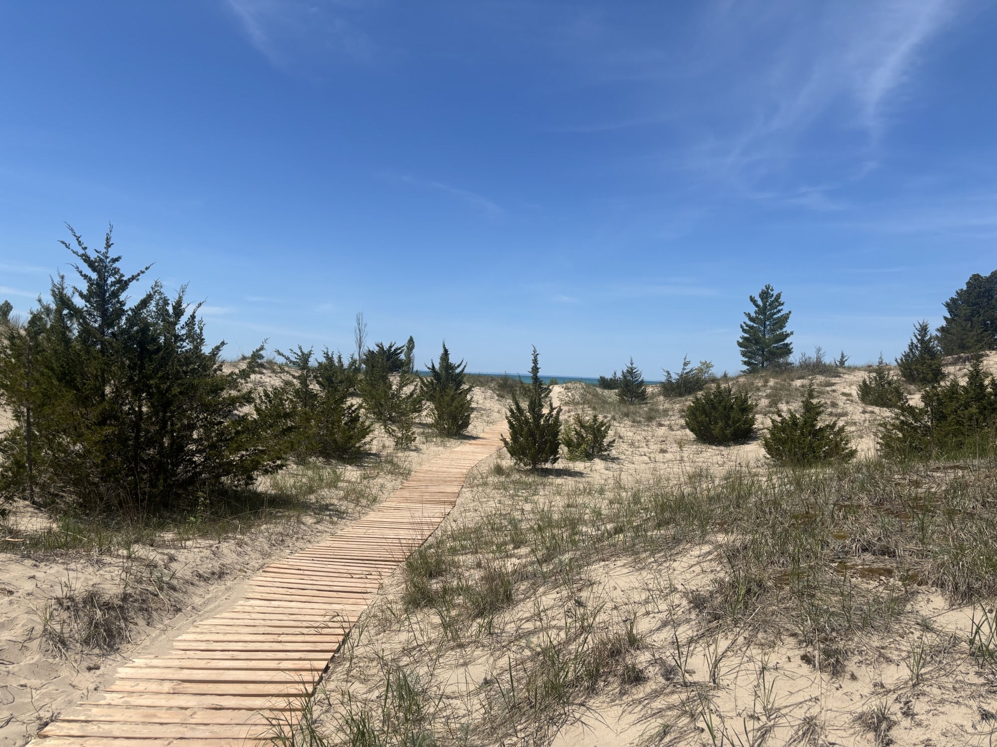
The next day was a relatively long drive to Pinery Provincial Park, That’s on the shores of Lake Huron, which I’ve never spent any time at before. The park was nice. There was a gigantic strip of sand dunes between the campsites and the beach. We camped in the loop they called “The Dunes”, which lived up to its name. It was very sandy, and some of the spots backed on to massive sand dunes that looked like they only had a few trees and some sedge grass keeping them from collapsing onto the campsite. Ours was a bit further away from the dunes, but still quite sandy. We were looking at the sites on the other side of our street as possibly a better option if we ever come back. And I hope we do come back, because it was a beautiful park and it had a lot to do.
The roads in the camp loop were kind of a maze. Most camp loops in our experience are just that, a loop, but this one had roads going off in all directions. Some of them weren’t roads, they just lead into two campsites sharing a driveway. It was so confusing I ended up giving our map of the campsites to a couple of girls who were very lost.
Once again, I’d chosen shade over Starlink, and so when it came time for my therapy appointment (not a euphemism) the phone call dropped several times and finally my therapist just refused to go on. In retrospect I probably should have disconnected from Starlink and just taken my chances with the cell network because I’m supposed to have unlimited phone and text roaming in Canada.
After the therapist, Vicki and I went for an absolutely beautiful bike ride. It was the longest ride I’ve had in about 3 years, which isn’t saying much because of my butt pain problem.
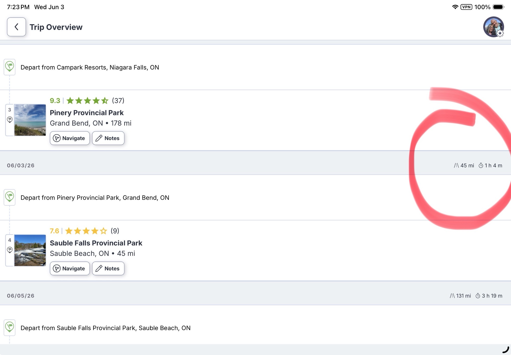
All through this process of taking my therapy appointment and then going for a bike ride, I’d been looking at the RV Life app on my phone, that said the next leg to my next campsite was only 45 miles, so a very light day. I should have thought about that, because one of the things I’d done a few weeks ago was drop some of the shorter leg days in favour of multi-day stays from my original route plan, which basically had us moving every day. But before we hit the road, we decided we needed to stop in Goderich on the way because I’d managed to ruin the gas hose for the Blackstone grill and I thought between the Walmart Supercenter and the Canadian Tire store in Goderich, I had a pretty good chance of finding some sort of substitute.
But when I put in the Walmart into RV Life to navigate, it told me that it was just over an hour away. Ok, I know Goderich was between where I was leaving (Pinery Provincial Park) and where I was going (Sauble Falls), so this was starting to make me feel like something might be wrong, but not enough to really investigate.
However, as we were leaving the Canadian Tire parking lot and I went to resume our trip to Sauble Falls, RV Life told me I had nearly 2 hours to go. Now I’m starting to really feel something is wrong. (Spoiler alert, I looked on my laptop the next day, and RV LIfe on my laptop was saying the trip from Pinery Park to Sauble Falls was 110 miles, not 45 miles. The iPhone and the iPad apps were still saying 45 miles. Sometimes I wonder about the quality of the programmers working for RV Life.
I really started to worry about the quality of the programmers at RV Life when we had a construction zone with a small road closure in Southampton Ontario. RV Life sent us down a street that suddenly ended in a bike path that it told us to continue down.
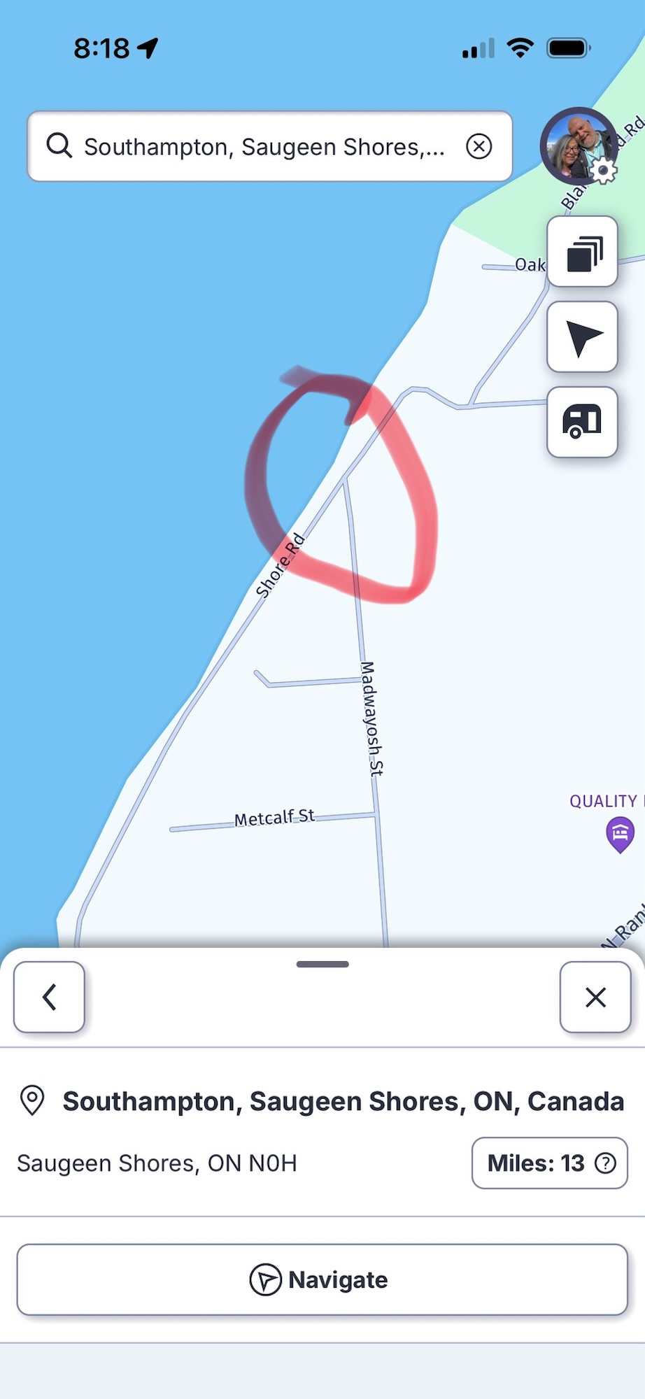
We were on Madwayosh St and it does NOT connect to Shore Rd. Have a look on Google Maps for the real situation. Good thing it was sort of a square cul-de-sac because I managed to make a 147 point turn and get turned around, and followed a better detour around the road closure thanks to Google Maps.
When we got to Sauble Falls Provincial Park, it was after 5pm and the office was closed. So lacking any signposting indicating which way to the camping area, we went straight ahead which lead us into a day use parking area that was almost, but not quite, wide enough to do one of my patented 147 point u-turns. I barely had to drive up into the picnic area at all, and I defy anybody to prove otherwise.
That’s when we discovered that if we’d taken a 90 degree turn after the office instead of going straight ahead, there was a large map board showing the campsites. Lacking an office to check in, I searched in my email to find out which spot we were supposed to camp in. Ok, so far so good. As we were in the campground loop, I recalled seeing indications of water spigots on the large map, but I couldn’t recall exactly where they were. I asked a friendly looking bunch of campers, and they said you couldn’t use those spigots for filling your fresh tank and you had to go to the other park of the park up the road a bit and fill out there. They even gave us a paper copy of the big map. So we went around the loop and out to the highway again, through the impenetrable and poorly signposted other part of the park, and filled up our fresh tank. Then we’d come back to the same loop, and given the paper map back to its original owners because it had phone numbers and names written on it and we figured they might need those. We then proceeded further down the loop to the spot we had reserved, only to find somebody parked in it. Probably just as well, because like several other campsites in this park, it was angled the wrong way and would have been damn near impossible to get our trailer into.
That’s when Vicki went searching and discovered that I was looking at an older email, and when I’d changed the booking from one night to two nights, they’d put us into a different campsite. Ironically the one right next to the friendly people we’d talked to before. So once more around the loop, and this time into our spot.
It had been a long day, and so basically we set up camp, did dinner, and went to bed.
Which is what I’m going to do now. I’ll tell you about the last couple of days in my next post.